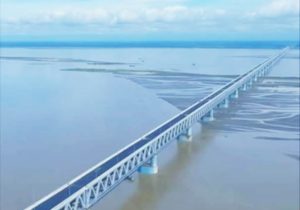
Bogibeel will span the Brahmaputra in eastern Assam
The Brahmaputra was till 1962 the only river in India that had not been bridged along its entire length either for road or railway, according to a 1988 book co-authored by former railwayman and IIT Madras teacher S. Ponnuswamy.
The river, more than 10 km wide in several stretches, now awaits the completion of its fourth and easternmost span — the country’s longest road-rail bridge at 4.94 km — that India’s defence forces and residents of the eastern half of the Northeast have been demanding for almost five decades.
“The Bogibeel bridge will usher in a new era of economic development in the region, apart from strengthening national security in the border areas,” AssamChief Minister Sarbananda Sonowal said, following a recent visit to inspect progress on the construction of the bridge.
Sited about 17 km downstream of Dibrugarh town, the bridge will facilitate road and rail connectivity between the north and south banks of the Brahmaputra in the eastern part of Assam and Arunachal Pradesh.
“A lot of emotion is attached to this bridge because it was part of the Assam Accord of 1985, but it is taking a long time,” said Lurinjyoti Gogoi, general secretary of the All Assam Students’ Union (AASU).
For the construction wing of the Northeast Frontier Railway (NFR) that is undertaking the project, it is better late than never given the unpredictability of the Brahmaputra and instability of its banks.
Training the river
While former Prime Minister H. D. Deve Gowda laid the foundation stone for the Bogibeel bridge in January 1997, work started only in April 2002, when Atal Bihari Vajpayee inaugurated the construction.
With several deadlines having been missed over the past 16 years, impatience has grown in the area. The NFR had set a June target, which was pushed back to October, and the latest indications are that the formal inauguration might be delayed by another couple of months more.
The protracted delay has resulted in the project’s cost increasing more than threefold to ₹5,800 crore, from the initial estimate of ₹1,767 crore.
At Bogibeel, the unpredictable river needed to be trained first for diversion through a narrower channel by constructing a total of 4.83 km of guide bunds, while flood dykes had to be raised and strengthened 9 km upstream and 7 km downstream on both banks.
Strategic span
“The actual work on the bridge began in 2011, and by that time we knew the guide bunds and dykes could withstand the river’s might,” a railway engineer, who did not wish to be named, said. The bridge has been designed for carrying very heavy loads and features dual broad-gauge tracks and a three-lane road.
“This is very strategic from the defence point of view, and the Army has been demanding it for years,” retired Brigadier Ranjit Barthakur told the media persons “The bridge classification is on the higher side for movement of heavy military equipment. It will drastically cut time for induction of troops and logistics during a war-like situation,” he added.
At present, troops moving between Dhemaji and Dibrugarh — districts on opposite banks — have to travel more than 600 km via the 3.015 km Kaliabhomora bridge, west of Bogibeel.
Ferry services could be hit
The Inland Water Transport (IWT) Department of Assam fears that the Bogibeel bridge will impact ferry services to a large extent. At present, one government vessel and 24 private boats ferry 2,500 people, 146 cars and 84 two-wheelers on an average every day, said Bharat Bhushan Dev Choudhury, director, IWT Department.
“We have to think of other ways to remain in business, such as long-distance cargo movement that works out cheaper than road transport,” Mr. Choudhury said.


